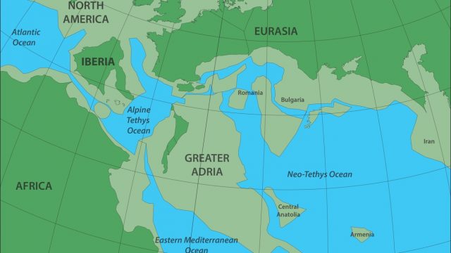
Scientists have discovered a continent under Europe, which broke off from North Africa and has been buried under Southern Europe for almost 140 million years.
The Mediterranean region is geologically one of the most complex regions on earth. Now the evolutionary history of the mountain ranges and seas in the region has been integrally reconstructed for the first time. Geologists from various countries realised this by investigating all the mountains ranges from Spain to Iran in detail for ten years. The research, coordinated by Utrecht University, reveals how a piece of continental crust the size of Greenland that once separated from North Africa plunged into the earth’s mantle under Southern Europe. ‘Forget Atlantis. Without realising it, vast numbers of tourists spend their holiday each year on the lost continent of Greater Adria.’
The results from the research will soon be published in the prestigious journal Gondwana Research. ‘Most mountain chains that we investigated originated from a single continent that separated from North Africa more than 200 million years ago,’ says principal researcher Douwe van Hinsbergen, Professor of Global Tectonics and Paleogeography at Utrecht University. ‘The only remaining part of this continent is a strip that runs from Turin via the Adriatic Sea to the heel of the boot that forms Italy.’ Geologists refer to that area as “Adria”. Van Hinsbergen has therefore called the lost continent “Greater Adria”.
Scrapings
Most of this continent was situated underwater and formed shallow, tropical seas in which sediment deposited, for example in large coral reefs. The sedimentary rocks, in particular, were scraped off when the rest of the continent subducted into the mantle. These scrapings are now the mountain belts of the Apennines, parts of the Alps, the Balkans, Greece, and Turkey.
A mess
The Mediterranean region is geologically among the most complex regions on Earth. Plate tectonics, the theory that explains the formation of continents and oceans, assumes that the various plates of the Earth do not internally deform when they move with respect to each other along large fault zones. However, in the Mediterranean region, and especially Turkey, that is not the case. ‘It is quite simply a geological mess: everything is curved, broken, and stacked. Compared to this, the Himalayas, for example, represent a rather simple system. There you can follow several large fault lines across a distance of more than 2000 km.’
Fragmented
The reconstruction was a collaboration between geologists from Utrecht, Oslo, and Zürich. Why did it take so long? Van Hinsbergen: ‘This is not only a large region, but it also hosts more than 30 countries. Each of these has its own geological survey, own maps, and own ideas about the evolutionary history. Research often stops at the national borders. Therefore, the region is not just fragmented from a geological perspective.’
Predicting
With their reconstruction of lost Greater Adria, the geologists have made a substantial contribution to fundamental knowledge about mountain range formation. ‘Subduction, the plunging of one plate under the other, is the basic way in which mountain chains are formed. Our research provided a large number of insights, also about volcanism and earthquakes, that we are already applying elsewhere. You can even predict, to a certain extent, what a given area will look like in the far future.’ In the short term, there are also economic aspects related to the research. Ore deposits and building materials that are vital to our society are found in mountain belts such as those in the area investigated. The geological systems in which these resources formed are fragmented together with the mountain belts that we reconstructed. The reconstruction is therefore useful in the search for new resources.’
Peeling off layers
For the reconstruction of this region, the geologists were the first to make use of the advanced plate tectonic reconstruction software GPlates. ‘And that started with manual work: the entering of thousands of pieces of information from the literature that say something about movement in the earth, such as fault lines and magnetism stored in the rocks. Thanks to this approach our method is simple to reproduce, and the reconstruction is independent of a wide range of other phenomena that we are trying to understand as a result of our research, such as volcanism, ore deposit formation, or biological evolution. Next, we peeled off the area layer by layer, back in time, as far as to the Triassic period, about 240 million years ago, when Greater Adria started to evolve as a separate continent. That peeling off is the only way to map the shape and size of the continent and the surrounding deep oceans millions of years ago. From this mapping emerged the picture of Greater Adria, and several smaller continental blocks too, which now form parts of Romania, North Turkey, or Armenia, for example. The deformed remnants of the top few kilometres of the lost continent can still be seen in the mountain ranges. The rest of the piece of continental plate, which was about 100 km thick, plunged under Southern Europe into the earth’s mantle, where we can still trace it with seismic waves up to a depth of 1500 km.’


