[ad_1]
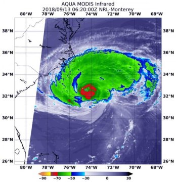
NASA’s Aqua satellite provided an infrared look at the large and powerful Hurricane Florence early on Sept. 13 that indicated wind shear was temporarily affecting the southern side of the storm.
The National Hurricane Center or NHC noted that hurricane-force winds extend outward up to 80 miles (130 km) from the center and tropical-storm-force winds extend outward up to 195 miles (315 km).
Infrared and Microwave Satellite Images Reveal
Early on Sept. 13, NASA’s Aqua satellite’s infrared data showed the clouds in the southern quadrant of Hurricane Florence appeared warmer than storms throughout the rest of Florence. That means that the cloud tops are lower in the atmosphere, and the storms are not as powerful. That’s because vertical wind shear, the change of speed and direction of winds with altitude was buffeting the southern side of Florence and preventing the development of higher, stronger thunderstorms in that part of the storm.
NOAA’s National Hurricane Center (NHC) said “microwave overpass indicated that the convection over the southern and southeastern portions of the storm is still disrupted, and that the eyewall was open to the southeast. It appears that some southern shear has caused the degradation of the inner core. The global models suggest that this shear will relax today while Florence moves over warm waters, however, given the current storm structure, little overall change in strength is anticipated as Florence approaches the coast.”
At 2:20 a.m. EDT (0230 UTC) on Sept. 13, Moderate Resolution Imagine Spectroradiometer or MODIS instrument aboard NASA’s Aqua satellite analyzed Hurricane Florence in infrared light. MODIS found coldest cloud top temperatures in a tight band around the eye wall (the thunderstorms surrounding the open eye), as cold as or colder than minus 80 degrees Fahrenheit (F)/minus 112 degrees Celsius (C). Surrounding the eye were thick rings of powerful storms with cloud tops as cold as or colder than minus 70F (minus 56.6C).
NASA research has found that cloud top temperatures as cold as or colder than the 70F/56.6C threshold have the capability to generate heavy rainfall.
Watches and Warnings Already in Effect
NHC noted s Storm Surge Warning is in effect for South Santee River, South Carolina to Duck, North Carolina and for the Albemarle and Pamlico Sounds, including the Neuse and Pamlico Rivers. A Storm Surge Watch is in effect for Edisto Beach South Carolina to South Santee River, South Carolina and north of Duck, North Carolina to the North Carolina/Virginia border. A Hurricane Warning is in effect for South Santee River, South Carolina to Duck, North Carolina and the Albemarle and Pamlico Sounds. A Hurricane Watch is in effect for Edisto Beach, South Carolina to South Santee River, South Carolina. A Tropical Storm Warning is in effect from north of Duck, North Carolina to Cape Charles Light Virginia, and Chesapeake Bay south of New Point Comfort.
Florence at 8 a.m. EDT on Sept. 13, 2018
At 8 a.m. EDT (1200 UTC), the center of the eye of Hurricane Florence was located by an Air Force Reserve reconnaissance aircraft and NOAA Doppler weather radars to be near latitude 33.1 degrees north and longitude 75.1 degrees west.
Florence is moving slower toward the northwest at about 12 mph (20 kph). This general motion, accompanied by a further decrease in forward speed, is expected to continue through today. A turn to the west-northwest and west at an even slower forward speed is expected tonight and Friday, and a slow west-southwestward motion is forecast Friday night and Saturday
Maximum sustained winds are near 110 mph (175 kph) with higher gusts. Little change in strength is expected before the center reaches the coast, with weakening expected after the center moves inland.
Florence’s Forecast Track
On the forecast track, the center of Florence will approach the coasts of North and South Carolina later today, then move near or over the coast of southern North Carolina and eastern South Carolina in the hurricane warning area tonight and Friday. A slow motion over eastern South Carolina is forecast Friday night through Saturday night.
For updated forecasts on Florence, visit: http://www.nhc.noaa.gov
Story Source:
Materials provided by NASA/Goddard Space Flight Center. Original written by Rob Gutro. Note: Content may be edited for style and length.
[ad_2]


