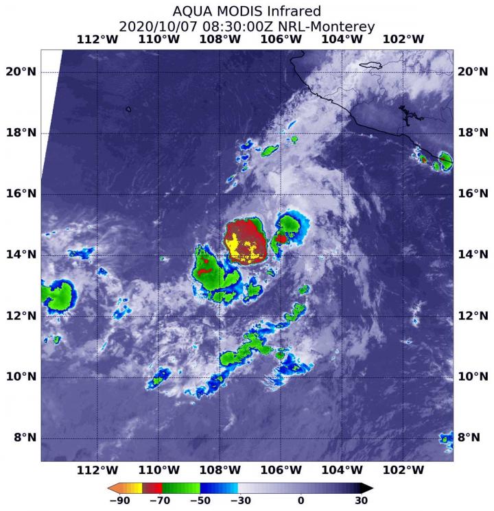
Photo: On Oct. 7 at 4:30 a.m. EDT (0830 UTC), the MODIS instrument aboard NASA’s Aqua satellite gathered temperature information about Norbert’s cloud tops. MODIS found a limited area of powerful…
view more
Credit Image: Credit Image: NASA/NRL
Infrared imagery from NASA’s Aqua satellite revealed that dry air is eroding Tropical Storm Norbert, located off the coast of southwestern Mexico.
Infrared Data Reveals Dry Air Effects
On Oct. 7 at 4:30 a.m. EDT (0830 UTC), the Moderate Resolution Imaging Spectroradiometer or MODIS instrument aboard NASA’s Aqua satellite gathered temperature information about Norbert’s cloud tops. Infrared data provides temperature information, and the strongest thunderstorms that reach high into the atmosphere have the coldest cloud top temperatures.
Dry air suppresses the development of thunderstorms that need warm, moist air to form. Dry air saps the moisture. Tropical cyclones consist of hundreds of thunderstorms. When their development is limited by environmental factors, they have difficulty strengthening and often weaken. The MODIS image showed fragmentation of thunderstorms around Norbert’s center as dry air affected development.
MODIS found that Norbert has weakened as entrainment of dry air has disrupted the compact system. The National Hurricane Center reported that Norbert’s center was partially exposed overnight, but recent infrared imagery shows a new burst of deep convection near the center. MODIS identified that burst of strong thunderstorms in infrared light, where temperatures were as cold as or colder than minus 70 degrees Fahrenheit (minus 56.6 Celsius). Cloud top temperatures that cold indicate strong storms with the potential to generate heavy rainfall.
Norbert’s Status on Oct. 7
At 5 a.m. EDT (0900 UTC), the center of Tropical Storm Norbert was located near latitude 14.0 degrees north and longitude 107.1 degrees west. Norbert is drifting toward the southwest near 1 mph (2 kph). The storm is forecast to meander or remain nearly stationary over the next couple of days.
Satellite-derived wind data indicate that maximum sustained winds have decreased to near 40 mph (65 kph) with higher gusts. Some fluctuations in strength will be possible during the next few days. The estimated minimum central pressure is 1005 millibars.
Norbert’s Future
Forecasters at the National Hurricane Center noted the forecast for Norbert over the next couple of days is challenging. “The intensity forecast for Norbert remains tricky given its small circulation and the presence of dry air in the surrounding environment. Sea-surface temperatures are more than sufficient for at least modest strengthening, but the question will be whether Norbert can survive the increased southeasterly shear that the SHIPS [computer forecast model] guidance calls for during the next 24-48 hours.”
NASA Researches Tropical Cyclones
For more than five decades, NASA has used the vantage point of space to understand and explore our home planet, improve lives and safeguard our future. NASA brings together technology, science, and unique global Earth observations to provide societal benefits and strengthen our nation. Advancing knowledge of our home planet contributes directly to America’s leadership in space and scientific exploration.
For updated forecasts, visit: http://www.
By Rob Gutro
NASA’s Goddard Space Flight Center
###
TDnews (tunisiesoir.com)


